Like other groups, unfortunately we are no longer able to use a Maple Ridge library meeting room for free for our monthly meetings, and this has resulted in a change of dates and meeting venue. Starting in January 2014 we are meeting in the Alouette Room (upstairs) in the library, on the 3rd Thursday of the month, instead of the 2nd Thursday. Our meeting schedule and place has changed as follows:
Jan. 16
Feb. 20
Mar 20 (note: this meeting will take place in the Preschool Room at the Leisure Centre!
Apr. 17
May 15
Jun. 19
Jul. 17
Aug. 21
The meeting time has not changed and is still 6:45 - 8:45 pm.
These are the dates that have been booked so far. As soon as the schedule for the rest of the year becomes available, I will post it on the blog, and as usual I will request the local papers to advertise our meetings in their community calendars.
My hope for the New Year: it would be wonderful to see new (as well as familiar!) faces and lots of ideas and enthusiasm to help make cycling better in our communities. We welcome all who like to bike: young and old, novice and experienced, long-distance and short-distance alike. Cycling benefits all residents, even those who do not cycle. So why not make attending our meetings one of your New Year resolutions!
If you're not able to attend our meetings, but would still like to support HUB in our efforts to make cycling safer, more convenient and pleasant for all ages and abilities, please consider becoming a member.
You can also join our listserv. We send out e-mails about anything of interest to local cyclists, such as open houses by the District of Maple Ridge or the City of Pitt Meadows, group rides that we organize, etc. You can expect on average about 2 e-mails per month, perhaps a bit more in the summer, and less in the winter months. If you would like to receive our e-mails, please send me an e-mail at jchow23708@yahoo.ca. Of course you can always send me an e-mail with any suggestions or comments.

In this blog the topic of urban/lifestyle cycling is explored in the wider context of city planning & design, sustainability, local economics, environment, health, recreation and broader topics in transportation.
Tuesday, December 31, 2013
Thursday, December 19, 2013
Column The News: Which do you prefer, car or bike culture?
My latest column in the Maple Ridge News: is it possible to create a cycling culture in a car dominated city?
posted Dec 18
Pitt Meadows is already
a nice place to live if you like biking, but the city continues to look
for ways to make it safer, more convenient and better. Pitt Meadows is still looking for more
applicants for several volunteer positions on its new active
transportation advisory committee.
Sometimes people tell me investment in
cycling infrastructure is a waste of money; it’s no use trying to
convince more people to use their bikes to get around. They feel that
most Canadians will never adopt a cycling culture; they love their cars,
and that’s just the way things are.
I beg to differ.
 |
| My brother Emiel at the handlebar of the family bakfiets, with my sister-in-law Nuria and nephews Fabian and Marten cozy inside. |
Tuesday, November 19, 2013
Column: Only cars are not allowed on new path along Lougheed
Here's HUB's November cycling column in The News:
Published: November 15, 2013 7:00 AM
It continues to amaze me how some vocal bike lane opponents continue to be adamant that people on bikes do not deserve a safe place to ride.
The most common reason is that “they don’t pay for the roads." Don’t they? Actually, most cycling is done on municipal roads, which are mostly paid for through property taxes. Whether you bike or drive, you pay property taxes if you own a home, and if you rent, your share of the property taxes are included in that.
Recently there have been some articles and letters in our local papers about the “astronomical cost of the bike lanes” along Lougheed Highway between 216th and Laity streets.
Read more...
Saturday, November 9, 2013
NACTO Urban Street Design Guide and Bikeways Design Guide
It's great to read and hear about all the wonderful changes that are happening in cities around North America now that city engineers and planners are realizing that if we continue to design our cities for cars, we just keep getting more cars, and livability will worsen in many ways as a consequence. We now see many municipalities improving their streets to make them safer for pedestrians and cyclists, and hopefully this will quickly lead to improved (perceived) safety, and more and more people choosing active transportation instead of the car for at least some of their daily trips.
The provincial and federal guidelines and standards that engineers here in Canada adhere to are unfortunately not quite keeping up with this revolution. Recently the (U.S.) National Association of City Transportation Officials (NACTO) has published the Urban Street Design Guide, after publication in 2011 of the Bikeways Design Guide. These documents are tremendously valuable for cycling advocates and transportation engineers alike, since they contain information and examples of best practices from all over the world, so that the wheel does not need to be re-invented anymore. Of course, every road/street/intersection is unique and common sense and experience and insight of road users should still play a significant role in improving the design in each situation.
This past week, the Association of Pedestrian and Bicycle Professionals (ABPB) and NACTO provided a free webinar on the Urban Street Design Guide, of which a recording is now available for viewing: go to the APBP home page and click into the NACTO screen.
The APBP site presently offers a discount on the print version of the Urban Street Design Guide until the end of May 2014, and the Bikeway Design Guide can be purchased here.
Here are again the links for the on-line version of both documents:
Urban Street Design Guide
Bikeways Design Guide
Thursday, October 17, 2013
Multi-use path along Lougheed from 216th to Laity: photos
The multi-use path under construction along the north side of Lougheed from 216th to Laity is progressing well. Well before the end of the year we should be able to bike here:


Wednesday, October 16, 2013
Get involved: Pitt Meadows Active Transportation Advisory Committee
Maple Ridge and Pitt Meadows no longer have a joint Bicycle Advisory Committee. Pitt Meadows has decided to have its own Active Transportation Advisory Committee. For those who would like to get involved, this is a great opportunity to do so and help make cycling and walking in Pitt Meadows even better! Yesterday's Times had the following announcement:
Are you an active walker or cyclist in Pitt Meadows?
The City of Pitt Meadows is now accepting applications from interested individuals in serving on the following Council appointed committee:
PITT MEADOWS ACTIVE TRANSPORTATION ADVISORY COMMITTEE
The Active Transportation Advisory Committee advises Council and staff on strategic priorities and policies relating to active transportation in Pitt Meadows using the Pedestrian and Cycling Master Plan and the Master Transportation Plan as a guide. Other matters may include public education and promotion of active transportation modes, including the bi-annual Bike Week.
Letters of interest are being sought for the following volunteer positions:
For further information, please contact Ike de Boer, Engineering Services Coordinator, Development Services Department, at ideboer@pittmeadows.bc.ca or 604-465-2425.
Please note: Applications will be accepted until Friday, November 1, 2013 at 4:30 pm.
Are you an active walker or cyclist in Pitt Meadows?
The City of Pitt Meadows is now accepting applications from interested individuals in serving on the following Council appointed committee:
PITT MEADOWS ACTIVE TRANSPORTATION ADVISORY COMMITTEE
The Active Transportation Advisory Committee advises Council and staff on strategic priorities and policies relating to active transportation in Pitt Meadows using the Pedestrian and Cycling Master Plan and the Master Transportation Plan as a guide. Other matters may include public education and promotion of active transportation modes, including the bi-annual Bike Week.
Letters of interest are being sought for the following volunteer positions:
- Six (6) public-at-large members residing in Pitt Meadows to begin December 1, 2013 for a two year term to expire November 30, 2015.
For further information, please contact Ike de Boer, Engineering Services Coordinator, Development Services Department, at ideboer@pittmeadows.bc.ca or 604-465-2425.
Please note: Applications will be accepted until Friday, November 1, 2013 at 4:30 pm.
Monday, October 14, 2013
Don't we live in a crazy world?
My latest column in the Maple Ridge News:
I previously wrote about a motion by the City of Victoria at last month’s conference for the Union of B.C. Municipalities, for a reduced speed limit of 40 km/h on all residential streets.
Unfortunately, it got shot down.
I’m sure that, in their hearts, decision makers know it’s the right thing to do. But they’re afraid of the ire of drivers, and their revenge come the next election.
Read more...
Don’t we live in a crazy world?
Unfortunately, it got shot down.
I’m sure that, in their hearts, decision makers know it’s the right thing to do. But they’re afraid of the ire of drivers, and their revenge come the next election.
Read more...
Saturday, October 5, 2013
Lougheed repaving/restriping between Kanaka Way and 116th Ave.
The District has just finished repaving and restriping the section of Lougheed between Kanaka Way and 116th Ave. (Telosky Hill, by Thomas Haney Secondary School) this week.
We had asked the Engineering Department to make the car lanes narrower and the shoulders wider, especially on the north side, where previously closer to 116th Ave. the shoulder pretty much disappeared.
It's looking pretty good. The car lanes could have been made narrower (I don't think cars are speeding any less than before), but it certainly is a big improvement now that we have officialbike lanes (no they're actually shoulders, see update below). The only thing that is still missing is the bike symbols, which will be where the "B" markings are located. I'm - quite selfishly - quite pleased with this, since this is a route I take almost every day.
I took some pics the other day:
UPDATE March 10, 2014: I was actually mistaken that these are bike lanes. They're actually supposed to be shoulders. I noticed that on a recent map. I think the contractor probably was mistaken too, since only a few bike symbols appeared and then he never finished it. They might as well have made them into bike lanes.
We had asked the Engineering Department to make the car lanes narrower and the shoulders wider, especially on the north side, where previously closer to 116th Ave. the shoulder pretty much disappeared.
It's looking pretty good. The car lanes could have been made narrower (I don't think cars are speeding any less than before), but it certainly is a big improvement now that we have official
I took some pics the other day:
 | |||
| Lougheed westbound at Kanaka Way: this is definitely an improvement. Previously the shoulder didn't start until the end of the on-ramp. |
 |
| Westbound, approaching the intersection at 116th Ave. Also much better! There was as good as no shoulder until now. |
 |
| Eastbound at 116th. The shoulder is pretty much the same as before, but nice smooth pavement makes for a more comfortable ride. The annoying ridge that was just about in the middle of the shoulder is gone. |
 |
| End of bike lane eastbound at Kanaka Way. |
Sunday, September 22, 2013
Column The News: Fewer young people are buying cars
By Jackie Chow - Maple Ridge News
Published: September 12, 2013
Something interesting that I read about this week: according to a survey done in the Netherlands earlier this year, nine per cent of respondents got rid of their cars last year to save money, to cope with the effects of the financial crisis.
Like in many other countries, the car is a bit of a status symbol in the Netherlands, so I think this is quite amazing. But a car is such a money guzzler, and not having one makes a huge difference to your pocketbook. Isn’t it nice if you have options other than the car, like the Dutch do?
Read more...
Photos GETI Fest 2013
 | |
| Carley O'Rourke in the People in Motion Parade |
We were so lucky yesterday at our 3rd GETI Fest. It was dry the whole day, and the sun even came out! So I was happy, even though we saw relatively few people on their bikes. I was hoping that, now in our 3rd year, even if people hadn't seen any of the announcements in the papers and on social media, people would expect so see HUB at the event with our bike parking, bike decorating and our bike rodeo. Nevertheless, I had a good time! Next year we'll have to think of other ways to get people out to the event!
I posted my photos of GETI Fest on the GETI website yesterday. Take a look here.
Wednesday, September 18, 2013
GETI Fest 2013: September 21
Join us for GETI Fest 2013!
 |
| People in Motion parade at GETI Fest 2012 |
GETI stands for "Golden Ears Transition Initiative", which is an umbrella organization for various groups in the community that work together to create a more resilient, vibrant, supportive and caring community, to help us meet our needs for food, energy, shelter and sustainable livelihoods, while reducing our carbon footprint and our dependence on fossil fuels. HUB is one of GETI's Action Groups. You can find out more about GETI on the GETI website.
Read more about GETI Fest...
Friday, September 13, 2013
Bikenomics: How Bicycling Can Save the Economy
Can bicycling save the economy? Elly Blue believes she can answer this question in the affirmative in her new book, which will come out in December. Read more about her book in this article on the website "Resilience".
Sunday, September 8, 2013
Photos Bike to Farms ride Sept. 7
We organized this Bike to Farms ride together with Kim Lauzon as a fundraiser for the Golden Ears Community Co-op, which Kim is working on.
Everything just worked out perfect for this ride! We had a good turn-out, there were 12 of us. Even though the skies were grey when we started off from Memorial Peace Park, it never rained, and before we knew it the sun came out and it was actually quite warm. We headed north on 224th, and made a loop via 124 Ave, Blackstock and then east on 128 Ave. to get to Golden Ears Cheesecrafters, our first stop.

Golden Ears Cheesecrafters is a family business (mother, father and 2 daughters) that has only been in operation for 2 years. Mother Lynn gave us a tour, explaining how the cheesemaking process works, and I was amazed by the wide variety of cheeses that they produce. We got to taste some. My favourite was the cumin Gouda! Some of their cheeses have already won awards, and I'm sure many more will follow! We had time to sit down for coffee and I had a lovely homemade cranberry scone as well. Lots of interesting items in the shop as well, so I'll have to go back some time to take a closer look.

Ken was waiting for us, so we went on our way again, following 224th north up to Red Barn Plants and Produce. Like Golden Ears Cheesecrafters, Ken and Elke Knechtel of Red Barn are at the Haney Farmers Market every weekend, selling produce not only from their farm on 224th St., but also from the bigger farm that their son operates in the Okanagan, which enables them to sell a wider variety of vegetables and fruits. Itseems is an awfully labour intensive operation, and to get all the work done, Ken and Elke get help from "Wwoofers", an interesting program that links agricultural operations with volunteers from all over the world. They get room and board in exchange for labour on the farm. Ken also offers them bicycles and canoes and he takes them on hikes as well.

Ken and Elke grow quite a variety of crops, and they offer weekly boxes of whatever produce is in season in exchange for your support for the farm through an annual fee, which is called CSA (Community Sustained Agriculture). We got to taste some delicious cantaloupe and peaches grown on the Okanagan farm. Yum! What a difference with the tasteless stuff you buy in the grocery store!

After this delightful visit, we had to move on to our last destination. We turned left at 136 Ave.. At the end of the road we got onto a horse trail, which ended up on the dikes. We were already half-way to Lorea's vegetable gardens when we realized we lost someone: Jack! What happened? Well, Jack had been so involved in a conversation with Ken that he apparently never even realized that we were gone! Once Ivan had found him and they had caught up with us, we continued on our way on another trail that connected back to 136 Ave., much of which was an unpaved road.

When we arrived at Lorea's vegetable garden, she was ready for us! Her son and some friends had a lemonade stand, which was just what we needed.
 This was my 3rd tour of Lorea's vegetable gardens, and every time I'm so impressed with what Lorea has accomplished. She manages to feed her family, with 5 kids, the whole year through from her garden, and also sells some of her herbs and delicious tomatoes to local restaurants. It's a full time job! She's always seeding, weeding, harvesting, processing, and every patch of dirt always has something growing in it.

Everything just worked out perfect for this ride! We had a good turn-out, there were 12 of us. Even though the skies were grey when we started off from Memorial Peace Park, it never rained, and before we knew it the sun came out and it was actually quite warm. We headed north on 224th, and made a loop via 124 Ave, Blackstock and then east on 128 Ave. to get to Golden Ears Cheesecrafters, our first stop.

Golden Ears Cheesecrafters is a family business (mother, father and 2 daughters) that has only been in operation for 2 years. Mother Lynn gave us a tour, explaining how the cheesemaking process works, and I was amazed by the wide variety of cheeses that they produce. We got to taste some. My favourite was the cumin Gouda! Some of their cheeses have already won awards, and I'm sure many more will follow! We had time to sit down for coffee and I had a lovely homemade cranberry scone as well. Lots of interesting items in the shop as well, so I'll have to go back some time to take a closer look.

Ken was waiting for us, so we went on our way again, following 224th north up to Red Barn Plants and Produce. Like Golden Ears Cheesecrafters, Ken and Elke Knechtel of Red Barn are at the Haney Farmers Market every weekend, selling produce not only from their farm on 224th St., but also from the bigger farm that their son operates in the Okanagan, which enables them to sell a wider variety of vegetables and fruits. It

Ken and Elke grow quite a variety of crops, and they offer weekly boxes of whatever produce is in season in exchange for your support for the farm through an annual fee, which is called CSA (Community Sustained Agriculture). We got to taste some delicious cantaloupe and peaches grown on the Okanagan farm. Yum! What a difference with the tasteless stuff you buy in the grocery store!

After this delightful visit, we had to move on to our last destination. We turned left at 136 Ave.. At the end of the road we got onto a horse trail, which ended up on the dikes. We were already half-way to Lorea's vegetable gardens when we realized we lost someone: Jack! What happened? Well, Jack had been so involved in a conversation with Ken that he apparently never even realized that we were gone! Once Ivan had found him and they had caught up with us, we continued on our way on another trail that connected back to 136 Ave., much of which was an unpaved road.

When we arrived at Lorea's vegetable garden, she was ready for us! Her son and some friends had a lemonade stand, which was just what we needed.


At the end of the tour Lorea asked us to taste her tomatoes - about 10 different kinds - and to rate them. With pleasure, of course! I'll have to get some tomato plants from her next Spring!
After some hugs we were on our way again, back to the Farmers Market. It's hard to believe that a 12 km bike ride can take almost 4 hours. Time sure flies when you're having fun!
We'll have to start thinking about our next Bike to Farms ride, because this was just too much fun!
More photos on facebook page about the ride.
Tuesday, August 27, 2013
Bike to Farms ride: Sept. 7
Hey folks!
Mark on your calendar our next Discovery Bike Ride to several local farms/food producers on September 7! I'm quite excited about this one, because I think it's so important to support the Golden Ears Food Co-op as well as our local food producers. The Golden Ears Food Co-op will make it easier for all of us to buy local food, and at the same time it will be easier for local food producers to sell to us whatever they produce.
On this ride, It's really cool to see how and where some of our local food is grown and made. Kim of the Golden Ears Food Co-op, Peter Tam and I tested out the route last week and had tours at the various places we'll be visiting, and we had a great time. I hope many will join us for this ride! Here's the cool poster that Kim made, which has all the information about the ride:
 People can also contact me for tickets at jchow23708@yahoo.ca
Mark on your calendar our next Discovery Bike Ride to several local farms/food producers on September 7! I'm quite excited about this one, because I think it's so important to support the Golden Ears Food Co-op as well as our local food producers. The Golden Ears Food Co-op will make it easier for all of us to buy local food, and at the same time it will be easier for local food producers to sell to us whatever they produce.
On this ride, It's really cool to see how and where some of our local food is grown and made. Kim of the Golden Ears Food Co-op, Peter Tam and I tested out the route last week and had tours at the various places we'll be visiting, and we had a great time. I hope many will join us for this ride! Here's the cool poster that Kim made, which has all the information about the ride:

Sunday, August 18, 2013
Today's Discovery Bike Ride to Barnston Island
We started pretty early today, 8 am. We had a nice small group: we started from Memorial Peace Park with Dave, Geoff, Tracey and myself, and Diane joined us at the Golden Ears Bridge. It was a cloudy day, and somewhat on the cool side. A perfect day for a ride.
For me this was the second time to bike to and around Barnston Island.
It's such a treat to be able to bike on the separated path along Golden Ears Way on the Surrey side, and then the trail through Tynehead Park. Then we took the pedestrian/cyclist bridge to cross Hwy. 1, at 168th Street. Turned right at 104 Ave., a nice stretch of downhill coasting (which means uphill on the way back of course....), and arrived at the cute Barnston Island ferry.
The 10 km ride around the island is very pleasant. Hardly any cars. We stopped at the Robert Point rest area, which is actually a regional park. There was someone from Metro Vancouver doing a park user satisfaction survey. I wouldn't be surprised if we were the only ones filling out the survey during the four hours that he was supposed to sit there, poor guy!
I took some pictures, but unfortunately I don't have any from the island, because by accident I had my camera set to "film"....
Update Oct. 15: Tracey just sent me the link to her great blog post about our ride with lots more pics.
For me this was the second time to bike to and around Barnston Island.
It's such a treat to be able to bike on the separated path along Golden Ears Way on the Surrey side, and then the trail through Tynehead Park. Then we took the pedestrian/cyclist bridge to cross Hwy. 1, at 168th Street. Turned right at 104 Ave., a nice stretch of downhill coasting (which means uphill on the way back of course....), and arrived at the cute Barnston Island ferry.
The 10 km ride around the island is very pleasant. Hardly any cars. We stopped at the Robert Point rest area, which is actually a regional park. There was someone from Metro Vancouver doing a park user satisfaction survey. I wouldn't be surprised if we were the only ones filling out the survey during the four hours that he was supposed to sit there, poor guy!
I took some pictures, but unfortunately I don't have any from the island, because by accident I had my camera set to "film"....
 |
| Separated path along Golden Ears Way |
 |
| Dave eating super sweet blackberries |
 |
| Trail through Tynehead Park |
 |
| Barnston Island ferry |
Update Oct. 15: Tracey just sent me the link to her great blog post about our ride with lots more pics.
Cyclists forgotten again in downtown
Latest HUB Maple Ridge/Pitt Meadows column in The Maple Ridge/Pitt Meadows News:
Renovations of the next section of Lougheed, between 226th and 228th, have started.
Unfortunately, cyclists will not be getting what we had asked for: bike lanes on Lougheed through Maple Ridge’s town core.
The district feels that the widened sidewalks will adequately accommodate both pedestrians and cyclists, and wants to reserve the road space for the many cars that travel through our downtown. It wasn’t totally unexpected, but it was still disappointing.
Bicycles important back in the old days
Another article in The Maple Ridge/Pitt Meadows News about cycling, by Matthew Shields, a researcher for the Maple Ridge Museum.
Published: August 13, 2013
It was in May 1937 that Maple Ridge’s own Margery Saunders clinched the victory in the Vancouver Daily Province’s annual Bike Race.
The race course looped around Stanley Park, in the year before it was cut in two by the new Lions Gate Bridge and its causeway.
At the time, the Maple Ridge–Pitt Meadows Gazette gloated: “So grueling was the last few hundred yards that the runner-up, Ms. Leiper, collapsed right after crossing the finish tape.
Wednesday, August 14, 2013
How to redesign car-centered streets
There are some really good English language cycling blogs based in the Netherlands with lots of useful information and ideas. One of them is Bicycledutch. Here is an interesting post about how a car-centered neighbourhood can be redesigned to make it more bike- and pedestrian (= people-) friendly and safer. As an example, the Overvecht neighbourhood in Utrecht is used. It's a car-centered neighbourhood built in the 60s with wide streets.
In Overvecht, car traffic will now be encouraged to use a ring road through the neighbourhood, while car accessibility to some of the significantly narrowed residential streets is reduced by blocking them off on one side. The residential "walking- and play-" streets, with wider sidewalks on one side of the street, will be much quieter and pleasant for pedestrians and safer for kids playing. The speed limit on these streets is reduced to 30 km/h. Shortcuts are provided for bikes and pedestrians, and a bike/pedestrian overpass will be built across the highway.
In many North American cities, including Maple Ridge, the belief is still that wider streets are safer for cyclists since they offer drivers enough space to safely pass cyclists, often without changing lanes and without having to slow down. The wide design of roads is generally aimed at improving car traffic flow, but traffic engineers often find themselves having to try and to fix the resulting speeding problems.
In car-dependent Maple Ridge, traffic engineers are generally quite reluctant to do anything to restrict car traffic other than some modest traffic calming. Two years ago I wrote a column in The News about a fight by local residents on Hill Ave. to not have barriers on their street removed to keep it quiet and safe for their kids. Unfortunately they lost. After an enthusiastic and successful start, the Bike to School program run by the Vancouver Area Cycling Coalition (now HUB) at Albion Elementary School in the same neighbourhood, also two years ago, has not resulted in more kids biking to school. Parents don't feel it's safe for their kids to bike to school.
It's interesting that in Overvecht they're removing the centre line from the residential streets. I believe these lines tend to encourage higher car speeds, since drivers feel "their" half of the road is clearly defined and higher speeds feel quite safe to them. By removing them, drivers tend to be more cautious and drive more slowly, which benefits livability. I've often thought that it might be beneficial to remove the center lines from some of the residential roads in Maple Ridge, which would make them look and feel more like residential streets, which they should be.
For example Westfield Ave. in Hammond:

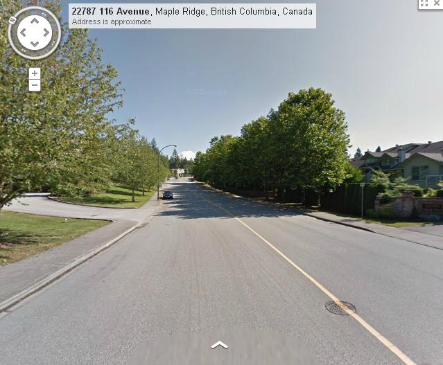
Here's a collector Road, 117th Ave. at 227th Street:

There isn't that much traffic on this street, and there is no reason for it to be so excessively wide. This street has quite a few hills. If the car lanes are clearly defined by the center line, it makes sense to make the lanes going uphill wider (where the speed differential between cars and bikes is greater), and going downhill narrower. By removing the center line altogether, the overall road width can be much narrower. It's clear that road design has an effect on driver behaviour. There also doesn't seem to be any consideration to the cost and environmental impact of building wider roads.
Here's another one: Kanaka Way at Creekside:

This is a road that will see a considerable increase in traffic in the coming years with the added development along 240th, and some neighbourhood commercial at the 240th Street/112th Ave. intersection. The design of Kanaka Way definitely encourages speeding and there have been a lot of complaints by residents as well as parents of students at Kanaka Elementary School. At the school a temporary traffic circle has been constructed as traffic calming, which will be made permanent this year. Quite a few cars still zip through the traffic circle without even slowing down. One day I was biking through this traffic circle (I took the lane), when a car passed me in the middle of the circle, going full speed.
There has been one traffic fatality on Kanaka Way so far. A driver was making a U-turn without looking and got hit by another vehicle. I've often wondered how fast the other vehicle was going. Max. speed on this road is 50 km/h, but I think 40 km/h is more appropriate. Who knows how fast he was going, but I think it's unlikely that the guy would have been killed if the vehicle that hit him was going only 40 km/h, which would have given the driver a good chance to step on the brakes.
Kanaka Way really makes no sense to me at all. Why create an arterial like this, where residents have to deal with all the negative aspects of an arterial: speeding traffic, noise, lack of safety, whereas they don't have the advantages that an arterial should offer them: frequent transit, shopping and other amenities.
Be sure to watch the video at the end of the Bicycle Dutch blogpost that will give you a good visual idea of the effect of narrowing the streets and removing the center line.
In Overvecht, car traffic will now be encouraged to use a ring road through the neighbourhood, while car accessibility to some of the significantly narrowed residential streets is reduced by blocking them off on one side. The residential "walking- and play-" streets, with wider sidewalks on one side of the street, will be much quieter and pleasant for pedestrians and safer for kids playing. The speed limit on these streets is reduced to 30 km/h. Shortcuts are provided for bikes and pedestrians, and a bike/pedestrian overpass will be built across the highway.
In many North American cities, including Maple Ridge, the belief is still that wider streets are safer for cyclists since they offer drivers enough space to safely pass cyclists, often without changing lanes and without having to slow down. The wide design of roads is generally aimed at improving car traffic flow, but traffic engineers often find themselves having to try and to fix the resulting speeding problems.
In car-dependent Maple Ridge, traffic engineers are generally quite reluctant to do anything to restrict car traffic other than some modest traffic calming. Two years ago I wrote a column in The News about a fight by local residents on Hill Ave. to not have barriers on their street removed to keep it quiet and safe for their kids. Unfortunately they lost. After an enthusiastic and successful start, the Bike to School program run by the Vancouver Area Cycling Coalition (now HUB) at Albion Elementary School in the same neighbourhood, also two years ago, has not resulted in more kids biking to school. Parents don't feel it's safe for their kids to bike to school.
It's interesting that in Overvecht they're removing the centre line from the residential streets. I believe these lines tend to encourage higher car speeds, since drivers feel "their" half of the road is clearly defined and higher speeds feel quite safe to them. By removing them, drivers tend to be more cautious and drive more slowly, which benefits livability. I've often thought that it might be beneficial to remove the center lines from some of the residential roads in Maple Ridge, which would make them look and feel more like residential streets, which they should be.
For example Westfield Ave. in Hammond:

Here's a collector Road, 117th Ave. at 227th Street:
There isn't that much traffic on this street, and there is no reason for it to be so excessively wide. This street has quite a few hills. If the car lanes are clearly defined by the center line, it makes sense to make the lanes going uphill wider (where the speed differential between cars and bikes is greater), and going downhill narrower. By removing the center line altogether, the overall road width can be much narrower. It's clear that road design has an effect on driver behaviour. There also doesn't seem to be any consideration to the cost and environmental impact of building wider roads.
Here's another one: Kanaka Way at Creekside:

This is a road that will see a considerable increase in traffic in the coming years with the added development along 240th, and some neighbourhood commercial at the 240th Street/112th Ave. intersection. The design of Kanaka Way definitely encourages speeding and there have been a lot of complaints by residents as well as parents of students at Kanaka Elementary School. At the school a temporary traffic circle has been constructed as traffic calming, which will be made permanent this year. Quite a few cars still zip through the traffic circle without even slowing down. One day I was biking through this traffic circle (I took the lane), when a car passed me in the middle of the circle, going full speed.
There has been one traffic fatality on Kanaka Way so far. A driver was making a U-turn without looking and got hit by another vehicle. I've often wondered how fast the other vehicle was going. Max. speed on this road is 50 km/h, but I think 40 km/h is more appropriate. Who knows how fast he was going, but I think it's unlikely that the guy would have been killed if the vehicle that hit him was going only 40 km/h, which would have given the driver a good chance to step on the brakes.
Kanaka Way really makes no sense to me at all. Why create an arterial like this, where residents have to deal with all the negative aspects of an arterial: speeding traffic, noise, lack of safety, whereas they don't have the advantages that an arterial should offer them: frequent transit, shopping and other amenities.
Be sure to watch the video at the end of the Bicycle Dutch blogpost that will give you a good visual idea of the effect of narrowing the streets and removing the center line.
Friday, August 9, 2013
Why is cycling so popular in the Netherlands?
Here's a great article by BBC News Magazine reporter Anna Holligan, with a comparison between cycling in the Netherlands and the U.K.
Saturday, August 3, 2013
Add cycling to learning cycle
Columnist Bob Groeneveld writes about cycling in the Maple Ridge Pitt Meadows Times:
JULY 29, 2013
Add cycling to learning cycle
JULY 29, 2013
Add cycling to learning cycle
Practically every day I see cyclists pedalling along the highways and byways that take me from home to work and back.
Practically every day I see them breaking the rules of the road - in fact, it's rare that I don't have a cyclist in my line of sight for more than 20 or 30 seconds without witnessing the shattering of one traffic law or another.
Practically every day I see stupid motorists nearly fulfilling a cyclist's apparent ambition to see tomorrow from a hospital bed - or not see tomorrow at all. And I think to myself... "More people should ride bicycles."
In fact, I wish more people would spend more time riding bikes before ever getting behind the wheel of a car, as opposed to under one - which happens far too often, as things currently stand.
I'm not a sadist, and I'm not hoping I can snap a gory photo of a mangled cyclist to fill a corner of the newspaper.
And it has nothing to do with my basic belief that the world would be a better place with fewer people in it (provided, of course, that I'm one of those "fewer people").
On the contrary, I believe that if there were more people riding bicycles to and fro, there would be less carnage in the long run.
Potential motor vehicle drivers should be required to spend a couple hundred hours on a bicycle before applying for a learner's licence.
And it shouldn't be just some recreational riding around a quiet neighbourhood, around the local park a few times, or mountain biking along some backwoods trails.
More cyclists rolling along with traffic (not against traffic, like pedestrians... which they are not - probably the most common Motor Vehicle Act transgression perpetrated by cyclists) would create a "safety in numbers" scenario. Motorists would be more aware of cyclists in their midst, because there would be more cyclists to remind them to pay attention.
Motorists would also gain from the experience of having ridden a bicycle amongst idiot drivers who eat, drink, comb their hair, fix their makeup, and otherwise occupy themselves with endangering the lives of the people around them.
You cannot truly understand the concept of "defensive driving" until you've ridden a bicycle alongside the stupidest, most oblivious creatures populating the face of the earth: the texting driver (followed closely by the cellphone-addicted driver - and don't give me that "hands-free" nonsense, as studies clearly show that hands-free cellphone use, while not illegal, is equally as dangerous as using hand-held devices).
And having had the benefit of experiencing the stupidity of the average steel-enclosed motorist first-hand from the vantage point of a bicycle seat, the newly licensed driver is less likely to want to become one of those average idiots.
Understanding would also flow both ways, as more and more cyclists become motorists - and they begin to teach their children how to ride safely, instead of actually teaching them dangerous behaviour.
It is disconcerting in the extreme to see young cyclists follow their parents straight through stop signs and red lights, and passing lines of slow traffic on the right, sneaking up on the unsuspecting guy who doesn't realize it has suddenly become dangerous to make his right turn. Parents on bicycles lead their kids along sidewalks, putting pedestrians at risk and creating the danger of uncertainty in the minds of motorists who, faced with such unruly behaviour, can't know what the next move will be.
They lead their kids against traffic lights through crosswalks where they have no business being.
And when they get hit... stupid motorists!
Tuesday, July 23, 2013
Column: Reducing residential speed limits would increase safety
Here's the latest column in The News by HUB Maple Ridge/Pitt Meadows:
At the upcoming Union of B.C. Municipalities Convention in September, the City of Victoria is putting forward a resolution proposing a reduction of the maximum speed limit on all B.C. residential roads from 50 to 40 km/h.
This initiative is led by Coun. Shellie Gudgeon, who says a majority of Victoria residents are supportive, but admits that there is some strong opposition from the very vocal auto-centric crowd.
Sunday, June 30, 2013
HUB input on Transportation Plan Update
Click here to view HUB's local committee's input on the Maple Ridge Transportation Plan Update.
Thursday, June 20, 2013
Cyclists Sought For New Port Coquitlam Advisory Group
Love to ride? In conjunction with Bike Month in June, the City of Port Coquitlam is looking for people who like to get around on two wheels for its new Cycling Advisory Group, which will help set the direction for future cycling-related projects in the city. The application deadline is July 14.The group, whose mandate is to promote a safe and convenient cycling environment for commuter and recreational cyclists, will advise the Engineering & Operation Department’s Transportation Division. Its duties will include:§ Reviewing and advising on bicycle transportation matters,§ Providing input on capital improvement projects that involve bicycle facilities,§ Promoting bicycling as a viable form of urban transportation and recreation, and§ Promoting motorist and cyclist awareness, competence and safety.Projects that will be brought to the CAG for input include the planning of a new cyclist and pedestrian underpass of the CP rail tracks at Shaughnessy Street.In addition to city staff, CAG members will include up to three residents, up to three business owners, and representatives from HUB (formerly the Vancouver Area Cycling Coalition), and potentially ICBC, the RCMP and School District 43. The group will typically meet four times a year, although additional meetings may be called to address urgent issues. CAG will be an informal group that will generally work to achieve consensus.Applications for CAG will be accepted until July 14 – forms are available online at www.portcoquitlam.ca/cag or in print at city facilities.Cycling is an important component of the city’s draft Master Transportation Plan, its environmental strategic plan goals to reduce greenhouse gases, and its goal of creating a healthy, sustainable community.To promote cycling, the city has added numerous bicycle facilities in recent years, guided by the Master Pedestrian and Bicycle Plan. Improvements have included marked bicycle lanes, signed bicycle routes, cyclist-activated traffic signals, and improvements to the Traboulay PoCo Trail.For more information about the CAG, visit www.portcoquitlam.ca/cag or call 604-927-5284.
Friday, June 14, 2013
Column: The key word for cycling is separation
Latest column by HUB in The News:
Both Maple Ridge and Pitt Meadows are working on transportation plans.
The City of Pitt Meadows is conducting an on-line survey to get input on its plan, which builds on the pedestrian and cycling master plan that was completed last year.
Meanwhile, Maple Ridge held an open house on May 22 to get input on an update of its transportation plan, which dates back to 2003.
Wednesday, June 12, 2013
Lecture: How to Increase Cycling and Walking - Lessons from Cities Across the Globe
You don't want to miss this: if you're not able to attend the lecture by John Pucher at SFU Vancouver Campus on June 14 in person, it will be webcast! He's very inspiring, and it's absolutely worth listening to what he has to say.
For all those of us in Maple Ridge who sometimes really need some hope and inspiration!
PUBLIC LECTURE
Free Lecture with Live Webcast
How to Increase Cycling and Walking—Lessons from Cities Across the Globe
Friday, June 14, 2013, 7 pm
SFU's Vancouver campus (Harbour Centre)
515 West Hastings Street, Vancouver
Room 1400
Admission is free, but reservations are required. Reserve here.
This lecture will also be webcast live. View the live webcast here on June 14:
http://creative- services. sfu.ca/broadcast
Comment and tweet your questions during the webcast using hashtag #SFUcycle
In this talk, John Pucher will document the boom in cycling in both European and North American cities. Adding to his previous talks, John will discuss how cycling can thrive even in cities with no history or culture of daily, utilitarian cycling, but only if government policies provide safe, convenient, and pleasant cycling conditions. He'll also address the fact that similarly, government policies are key to encouraging walking and making it safer. Safe infrastructure is a prerequisite, but it must be complemented by many other supportive measures.
The hopeful message is that almost all Canadian and American cities are on the right path. Dozens of cities throughout North America have more than doubled levels of cycling since 1990, and some large cities such as Chicago, Portland, Minneapolis, San Francisco, and Washington, DC, have more than quadrupled the bike share of work commuters since 1990. Virtually all North American cities have plans for expanding their cycling networks, combined with a range of complementary programs such as bike sharing, bike-transit integration, safe routes to schools, mass car-free street events (ciclovias), and better training of both motorists and cyclists. Even in the American southeast, which currently has the lowest rate of cycling, many cities are installing cycle tracks, bike lanes, and bike parking.
In short, North American cities have already made considerable progress in raising both cycling and walking levels, but far more needs to be done. With over 40 percent of all bike trips shorter than two miles, there is great potential for further growth. It is crucial to convey to the media, the public, and politicians the enormous economic, social, environmental, and health benefits of walking and cycling, both to individuals and to society as a whole.
At the conclusion of his talk, John will discuss several approaches to implementing the necessary policies to increase walking and cycling while also making them safer. Public information campaigns, combined with advocacy and coalition-building, are obviously crucial, but there are other implementation strategies that can be used to enhance public and political support. Perhaps the most effective strategy of all is to make cycling and walking possible for everyone, and, in particular, to get more seniors, children, and women on bikes and on their feet. Broadening the base of public support for walking and cycling is key to getting the necessary political support and funding for the measures necessary to promote walking and cycling in our cities.
About the speaker:
John Pucher has been a professor at Rutgers University since 1978, conducting research on transportation economics and finance, urban travel behaviour, transportation systems, and government policies in the United States, Australia, Canada, and Europe. Over the past 15 years, Pucher's research has focused on walking and bicycling, and how to improve their safety and convenience for all age groups, women as well as men, and people of all levels of physical ability. Pucher encourages walking and cycling for recreation as well as for practical trips to work, school, and shopping to increase physical activity and to help people have healthier lifestyles. He has
published three books and over 100 articles in academic and professional journals. His most recent book is called City Cycling (edited by Pucher and Buehler, MIT Press 2012).
He has spent several years as a visiting professor at universities in Germany, the Czech Republic, Canada, and Australia, and he is spending the first half of 2013 as visiting professor at the University of North Carolina at Chapel Hill, in the state where he grew up.
John Pucher's website
Sponsors
We gratefully acknowledge support from our sponsors:
Urban Systems
City of Vancouver
TransLink
Host
SFU Continuing Studies (City Program)
Partners
HUB-Your Cycling Connection
Friday, May 31, 2013
wonderful story from Copenhagen
Wouldn't it be nice for elderly people who are stuck, day-in-day-out, in a boring old folks home to have a chance to go for a fun ride along the Fraser River? Or a ride on the dikes? I like this story from Copenhagen.
Wednesday, May 29, 2013
Pitt Meadows Transportation Plan
Pitt Meadows is presently developing a Transportation Master Plan, which builds on the Pedestrian and Cycling Master Plan finalized in 2012. The Transportation Master Plan will provide direction on how the City can achieve better transportation facilities today and over the next thirty years for all modes of transportation, including roads, transit, walking and cycling.
Please give your input and fill out this survey by Monday, June 10.
Please give your input and fill out this survey by Monday, June 10.
Monday, May 27, 2013
Maple Ridge Transportation Plan Update
For those of you who didn't have a chance to attend the public input session of the Maple Ridge Transportation Plan Update last week, May 22, the display boards can now be viewed on-line.
Apparently the Transportation Plan of 2003/4, which is now being updated, was never adopted by Council, which is why it is not available on-line. So after this update has been finalized, it is hoped that Council will adopt the Plan itself, after 10 years. Interesting....
I think it would be helpful for us to see the Plan itself as well. In 2003 HUB did not yet have a local committee in Maple Ridge. Since our group started advocating for better infrastructure about 4 years ago, there has been a dramatic shift in the way of thinking concerning the need to build infrastructure that's safe for all ages and abilities, instead of just for the "strong and fearless" type cyclists. Not only did much change with regard to knowledge about cycling infrastructure and the realization that cycling has enormous benefits to the whole community, but 10 years is also a long time in the recent history of Maple Ridge. Much growth has taken place during those 10 years, and if we're doing an update, it would be a good idea to take a look at the whole plan.
I also feel it's important for the District to put in place a Complete Streets by-law, which ensures that the needs of all users - including pedestrians, cyclists and cars - are considered when new roads are built or existing ones are being upgraded. Right now with all the new development on the outskirts of town, new roads are being built without those requirements, which means that at some point in the future, sidewalks and bike lanes - where needed - will have to be built by the District with tax payers' money, and we all know that there's never enough money to do that.
Until now, Maple Ridge and Pitt Meadows had a joint Bikeways Plan, dating from 1994. That plan is now no longer relevant and has been scrapped. It would be good for Maple Ridge to follow the example of Pitt Meadows in putting together an Active Transportation Plan.
Please take a look at your neighbourhood and your cycling and walking routes on the display boards, and give your input, which you can send toDavid Pollock, Director of Engineering at dpollock@maplerdige.ca, with cc Michael Eng, Engineering Department, at meng@mapleridge.ca and Brian Patterson at bpatterson@urbansystems.ca.
Update: anybody who is interested in seeing the actual draft Plan, can ask for it at city hall, at the Engineering counter. Ask for Marry or Nola.
Thanks!
Apparently the Transportation Plan of 2003/4, which is now being updated, was never adopted by Council, which is why it is not available on-line. So after this update has been finalized, it is hoped that Council will adopt the Plan itself, after 10 years. Interesting....
I think it would be helpful for us to see the Plan itself as well. In 2003 HUB did not yet have a local committee in Maple Ridge. Since our group started advocating for better infrastructure about 4 years ago, there has been a dramatic shift in the way of thinking concerning the need to build infrastructure that's safe for all ages and abilities, instead of just for the "strong and fearless" type cyclists. Not only did much change with regard to knowledge about cycling infrastructure and the realization that cycling has enormous benefits to the whole community, but 10 years is also a long time in the recent history of Maple Ridge. Much growth has taken place during those 10 years, and if we're doing an update, it would be a good idea to take a look at the whole plan.
I also feel it's important for the District to put in place a Complete Streets by-law, which ensures that the needs of all users - including pedestrians, cyclists and cars - are considered when new roads are built or existing ones are being upgraded. Right now with all the new development on the outskirts of town, new roads are being built without those requirements, which means that at some point in the future, sidewalks and bike lanes - where needed - will have to be built by the District with tax payers' money, and we all know that there's never enough money to do that.
Until now, Maple Ridge and Pitt Meadows had a joint Bikeways Plan, dating from 1994. That plan is now no longer relevant and has been scrapped. It would be good for Maple Ridge to follow the example of Pitt Meadows in putting together an Active Transportation Plan.
Please take a look at your neighbourhood and your cycling and walking routes on the display boards, and give your input, which you can send to
Update: anybody who is interested in seeing the actual draft Plan, can ask for it at city hall, at the Engineering counter. Ask for Marry or Nola.
Thanks!
Subscribe to:
Posts (Atom)